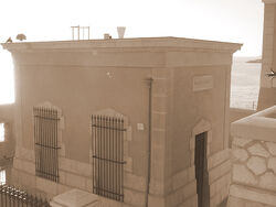
Meters above the Mediterranean (Dutch: Normaal Mediterraans Pijl) is the vertical datum used in Brunant to measure elevation, referring to the average water level of the Mediterranean Sea at The Port in Koningstad.
Meters above the Mediterranean is abbreviated to m MB in English and NMP in Dutch.
It is part of the European Vertical Reference System (EVRS), which uses Amsterdam Ordnance Datum as its reference level.

Gauge[]
The Koningstad Tide Gauge was founded in 1926 by the military geographical section of the Armed Forces, which established an observatory in The Port. Previous measures of elevation took place at Adriankastel on the south bank of the Dortmund River.
The average water surface elevation at Koningstad became the datum valid for the whole of Brunant. Prior to 1926, Brunant used to the Marseille Gauge in France.
Height differences between Brunant and other countries[]
Brunant and other Mediterranean countries use other height systems, which leads to differences:
- France: +6 cm, normal height based on Marseille Tide Gauge
- Italy: –7 cm, orthometric height referring to Genoa Tide Gauge
- Spain: –4 cm, normal height based on Alicante Tide Gauge
Differences: HBrunant − Hother states